2013-2014 excavations
The stratigraphic basin investigated covers the entire chronology of Torcello, from Late Antiquity to the Early Middle Ages, the central centuries of the Middle Ages and the Modern Age, up until present day.
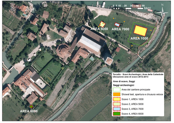
Four different areas were opened up as well as 3 small test areas for stratigraphic surveys, partly related to the laying of services to the site.
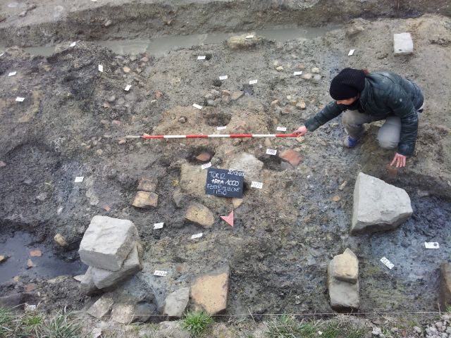
Three of the areas of the main excavation (areas 1000, 5000, 6000, and 7000) are in cadastral parcel no. 112/113, an area located in a field which is today used as a garden, to the north of the Basilica. A further excavation area (area 6000) was opened near the garden of the former elementary school of Torcello (cadastral parcel no. 187). These areas are all on land owned by the municipality of Venice.

Area 5000: the first settlements, early medieval warehouses and traces of dwellings
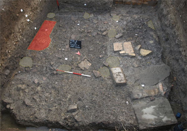
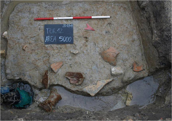
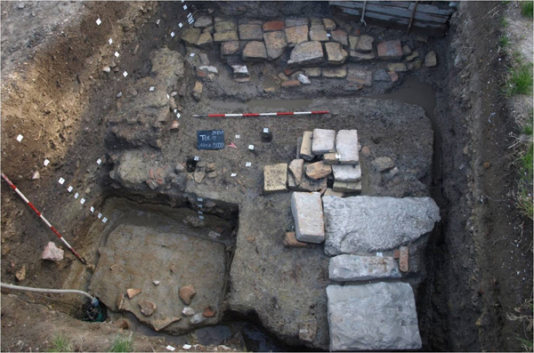
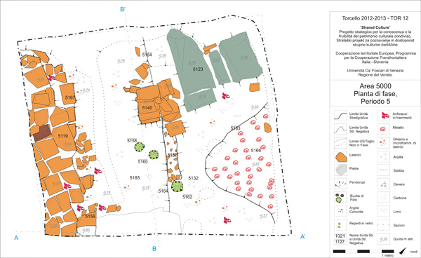
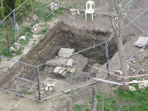
The survey opened in area 5000 has a 16 m² extension, to which a small exploratory adjacent trench was opened (2.5 x 1.5 m), in order to verify the size of the Venetian well. The maximum depth of excavation reached was 2.30 m from ground level, i.e. up to -1.06 m above average sea level. In total, approximately 36 m³ of soil were excavated by hand, with around a third related to the contemporary phases, a third to the Modern Age and, finally, a third with perfectly preserved stratification from the Antiquity, Late Antiquity and Early Middle Ages.
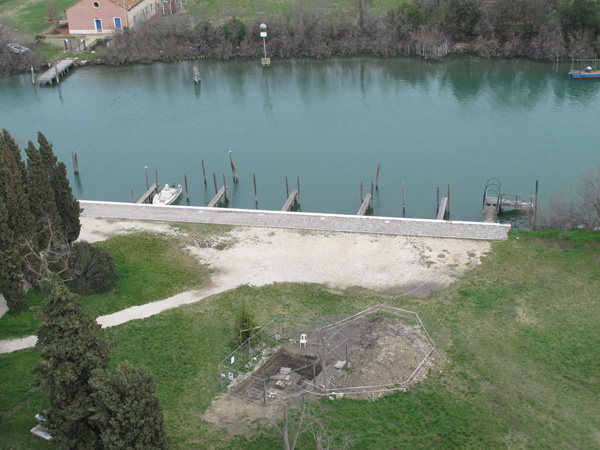
Today, the area is located in a field used as a garden near the basilica (northern side). It is occupied by a few tall fruit trees and was not affected by contemporary constructions.
The dig reached depths below sea level; however, dry excavation was made possible by the construction of drainage canals along three of the four sides of the area. Just a fraction (about 4 m3) of the archaeological stratigraphy was sacrificed to allow for dry excavation. However, the small canals were gradually lowered by hand whilst the stratigraphic excavation was carried out: this allowed the whole area of the excavation to be kept dry while the stratigraphic ratios were controlled between the sections and levels before carrying out further deepening of the drainage canals. A wellhead for the pumps, in operation 24/7 was located in the north-western corner of the excavation.
Period VIII
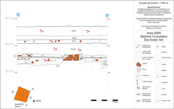
Period VIII corresponds to the earliest phase identified in area 5000, as well as to the entire area surveyed. It coincides with a series of layers of a silt based and silt-clay matrix, with the characteristic blue-light blue colour, testimony to a clearly natural formation in the lagoon environment, close to a bank on the edge of a canal. The formation of (stratigraphically) higher silts can be dated to around the 1st century BC, based on the ante quem of the absolute chronology obtained from the ceramic context brought to light in the period immediately after this.
Period VII
The first period with noticeable human presence is found in the excavation of US 5165, or rather a loose, sandy silt layer with a high quantity of malacofauna, characterised by the presence of micro fragments of land fauna and some fragments of brick. The layer seems as if it was slow to form, determined by deposits moved by the tides. Above this is a large, rather compact clay filling layer, markedly yellow in colour. This artificial filling layer was probably contained by a wooden bank (only partially visible in this section of the excavation) and reinforced on the top section by horizontal wooden planking connected to this bank. The yellow clay layer (US 5170) is full of large pieces of amphorae, bricks and limestone, used for drainage or consolidation. This suggests the use of a wooden pier, also acting as a bank. It was most probably used to both raise and border off the internal walking surfaces, and to improve mooring for boats. The ceramic pottery (especially amphorae) classifies such construction activity between the end of the 1st century BC and the 1st century AD.
The wooden parts (horizontal planks and vertical poles) show widespread traces of burning, probably due to a fire.
Period VI
The following period saw the construction of a pier with a more majestic form, made from stone (greenish limestone mark) which was almost certainly re-used, securely positioned above a strong ‘caranto’ layer (30-40 cm thick). The ‘caranto’ is a very old, extremely compact clay paleosol (Pleistocene), characterised by a light brown colour with streaks of ochre. There are doubts whether it is an artificial layer: in the lagoon these sediments are too deep to be easily excavated, while on the border of the lagoon, lines of caranto may be found close to the ground surface. Moreover, the layer is made up of large pieces of material, compact and placed in a regular pattern, alternating larger pieces with smaller nodules. No archaeological material is present within the deposit.
These works on the bank (note here that we are talking of an area situated a few metres from the portico of the Basilica of Santa Maria Assunta), suggest a certain financial commitment and a substantial commitment of labour and resources. In fact, caranto was chosen as the material for raising the land - given its excellent insulating capacity – and was brought to Torcello from outside the lagoon. Furthermore, a series of stones were also transported – undoubtedly many more than those visible, as part of a system – to set up a bank able to withstand large and heavy loads. The stones were re-used for building the pier, as is confirmed by their irregular size and shape.
These works on the bank were not an impromptu activity, but part of a project to redevelop the area. The dating of such activity was, once again, obtained in relation to events in the successive phase. The archaeological materials associated to the life of this structure are in fact meagre. However, it is plausible that little time passed in between the creation of the bank and the construction of the stone building in the subsequent period.
Torcello, Excavation 2012-13
Roman Brick Virtual Restoration
From the ground to the interpretation
G. Trombin, D. Calaon
Period V
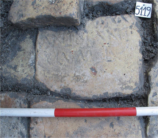
In period V, the foundations of a building were excavated, laid entirely in re-used bricks (mostly split up into ‘sesquipedal’, bricks one and a half foot long), represented by an east-west perimeter. The excavation revealed just over 3 m of the building’s foundations, and a corner of the same building located on the western side. The internal floors would have extended towards the current basilica. On the outside, towards the canal, there is a square plinth, with a foundation of around 80 x 80 cm and a height of 60 × 60 cm, entirely formed – also in this case – by split Roman bricks, clearly re-used. The foundations of both the structures, the wall and the plinth, are formed from small fragments of brick, fragments of limestone (Istrian stone) and marl. The foundation trenches are not very deep or wide. In fact the foundation footing is preserved in situ (the elevation of the building was not preserved), but it seems that the raised wall was not bound with mortar, but only by layers of clay. Nonetheless, it is imagined that the building was considerably tall: this is implied by the presence of scaffolding holes, needed to build a wall of a certain height. The fact that it was a building constructed from brick is shown by the presence of the plinth, identified as the base of a pillar with the function of supporting a portico. The building was constructed after the area had been levelled and made even: an action visible in US 5164. This action served to prepare the area for the foundations of the building and the plinth at the same height, as part of a careful construction plan, born from a specific design.
With regards to the function of the building, it is thought to have been a warehouse. This hypothesis was suggested by multiple elements. Firstly, there is its topographic position, or the location of the building beside the canal, near to a stone pier, functional for loading and unloading operations. Then, the presence of a portico on the canal side would allow storage even in adverse weather conditions. Furthermore, the size of the foundations, at least 80 cm wide, suggests a wall of certain strength. Finally, there is the quality of the associated findings, with 95% of the ceramics collected belonging to containers (amphorae). It does not seem plausible that it could have been a house, both because of the total lack of ceramics for tableware or cooking, and because of the type of the portico (too large in appearance).
Period IV
In the following period, all the elevated construction elements of the building were systematically removed. The excavation revealed signs of a series of holes referring to a residential building, built completely out of perishable material. Due to the size of the excavation, the actual dimensions of this building could not be known; however, it is believed that it was rectangular shaped. The posteriority of the pole impressions is shown by the fact that some of the building’s bricks underneath were re-used, moving them slightly and re-adapting them, to become reinforcement wedges used to hold the poles in place in the holes. This phase also included a series of alternating layers (two by two) of pure yellow clay, alternated with black anthropic layers. Although excavated from a small test excavation, to highlight similarities with other excavation areas (see area 6000 infra) and with excavations from the past, these layers can be certainly ascribed to periods of early medieval inhabitation. The clay corresponds to the filling levels on which the walking surfaces of the houses were found. The black layers are very ‘anthropic’, i.e. mostly formed from organic elements, such as the remains of food and fragments of wood and carbon: they represent the life levels of the houses.
The last of these dwellings (or rather the last action of this habitation phase) is the best preserved aspect in the excavation. It can be dated between the 7th and 9th centuries. Yet again, this is a house constructed on a rectangular frame of poles fixed in the ground, with the short side measuring a little less than 3 metres. The clay floor is characterised by the preservation of a large domestic hearth in a rather central position. It is rectangular, with a side that measures 1.1 m built with stone and brick waste (obviously re-used) and a level of clay that has major traces of ‘concottura’ and burning, the results of prolonged exposure to fire. The domestic function of the hearth was confirmed by the large presence of food (fauna and malacofauna), the presence of ceramic tableware as well as containers for heating food.
Period III
Period III is marked by an abrupt chronological transition. The residential areas of the Early Middle Ages is cut through by an agricultural layout (negative stratigraphic unit US 5185) giving rise to a silt-clay matrix, rich in organic materials (US 5118). The way this layer is laid and the fragmentation of the anthropic elements within it, suggest the conversion of the area into orchards or gardens. The materials can be referred to the 14th century; however, there are no indications for the core of the Middle Ages.
Periods II and I
The most recent phases refer to a series of levels relative to the agricultural use of the entire field between the 18th and 19th centuries. As for area 1000 (see further), the impression of one of the small drainage canals can be seen, running from east to west, with the function of keeping the vegetable growing areas dry and – above all – with the function of evacuating high salty waters as quickly as possible. The small canal divided trunk shaped plots for agricultural ground crops (vegetables) in exactly the same way as those excavated in area 1000. It was filled by a series of dark, silty layers, richly organic, the upper levels of which contain modern findings (including plastic) and therefore confirm disuse of the drainage system only in the second half of the 20th century. The nearby well remained in use along with the area used for a vegetable garden.
Last update: 17/04/2024